Key Issues
- DDW requires demonstration of 60% RWC in a monitoring well located within 12 months' travel time from the WCBB
- Aquifer system complexity, variable injection rates and injection water RWC, and long injection and monitoring well screens make meeting DDW requirements a challenge
Solutions
- Fully characterize the complex hydrogeology and injection rates and injection water RWC over time
- Use intrinsic tracers and detailed analysis to demonstrate travel time and RWC
- Conduct an added-tracer study
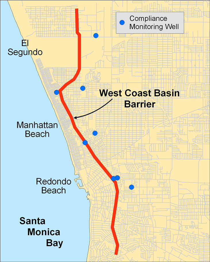
West Coast Basin Seawater Intrusion Barrier Intrinsic Tracer Study
West Coast Basin
Los Angeles County, California
In the early half of the 20th century groundwater pumping in the West Coast Basin in Los Angeles County lowered groundwater levels to over 100 feet below sea level, resulting in seawater intrusion of coastal areas. For over 50 years the West Coast Basin Barrier Project (WCBBP) has been operated to protect groundwater from seawater intrusion. The WCBBP includes a series of injection wells, which form a pressure ridge to repel seawater.
The WCBBP originally injected imported potable water, but since 1995, a blend of potable and advanced treated recycled water (RW) has been injected. Currently, the maximum allowable recycled water content (RWC) in injected water is 75%.
The Los Angeles Regional Water Quality Control Board has authorized injection of 100% RWC, but prior to proceeding to 100% RWC, the West Basin Municipal Water District (District) must satisfy California Division of Drinking Water (DDW) (formerly Department of Public Health) requirements verifying travel time through, and RWC in, one or more of the three West Coast Basin aquifers. Specifically, the District must demonstrate 60% RWC in a monitoring well located within a 12-month travel time from the barrier, in order to provide an early-warning system and to demonstrate understanding of the groundwater flow regime.
Meeting the DDW requirements has proved challenging, due to aquifer system complexity, variable injection rates and injection water RWC, and long injection and monitoring well screens. To meet these challenges, Todd Groundwater has applied several hydrogeologic and geochemical techniques including:
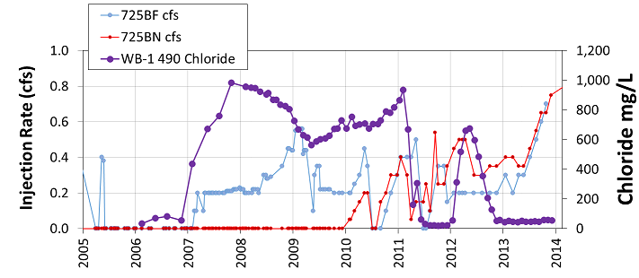
- Analysis of single constituent concentration trends using intrinsic tracers including: sodium, calcium, chloride ions, sulfate ions, TDS, and n-nitrosodimethylamine (NDMA)
- Analysis of ratios of stable isotopes
- Brine Differentiation Plots (BDP) — a powerful tool generally used to identify different brine source waters
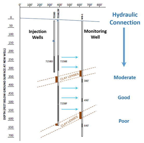
- Examination of the hydraulic connection between injection and monitoring wells
Preliminary results using intrinsic tracers indicate that DDW requirements are being met.
Additional monitoring combined with improvements in estimating existing RWC in blended injection water have been recommended by DDW to verify the findings of the initial investigation. To support continued analysis the District, Water Replenishment District of Southern California, California State University East Bay, and Lawrence Livermore National Labs have proposed an added-tracer study using the noble gas xenon.